Monsterorkan försvagad – ”Kan inte slappna av än”
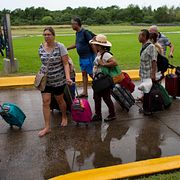
I natt svepte orkanen Patricia in över Mexikos Stillahavskust som den kraftigaste på det västra halvklotet någonsin. Under morgonen har stormen nedgraderats, från kategori fem till kategori ett.
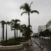
Med en vindstyrka på 72 meter per sekund drog Patricia fram med mindre förödelse än väntat. Vinden piskade kusten med visslande regn, avbrutna palmträd och skräp förvandlat till små projektiler, skriver CNN.
– Med den information som finns tillgänglig nu och med hänsyn till att väderfenomenet fortfarande pågår, bekräftar de första rapporterna att skadorna har varit mindre än de som motsvarar en orkan av den här storleken, sade presidenten Pena Nieto i ett tv-sänt tal.
bakgrund
De flesta kategori fem-stormar på Stilla havet drar mot Mexiko
Wikipedia (en)
Category 5 hurricanes are tropical cyclones that reach Category 5 intensity on the Saffir-Simpson Hurricane Scale. They are by definition the strongest hurricanes that can form on planet Earth. They are rare in the eastern Pacific Ocean and generally form only once every several years. In general, Category 5s form in clusters in single years. Landfalls by such storms are rare due to the generally westerly path of tropical cyclones in the northern hemisphere.
The term "hurricane" is used for tropical cyclones in the Pacific Ocean, north of the equator and east of the international date line. A Category 5 Pacific hurricane is therefore a tropical cyclone in the north Pacific Ocean that reached Category 5 intensity east of the international dateline. Identical phenomena in the north Pacific Ocean west of the dateline are called "typhoons" or "super typhoons". Category 5 super typhoons generally happen several times per season, so cyclones of that intensity are not exceptional for that region. This difference in terminology therefore excludes storms such as Super Typhoon Paka, Super Typhoon Oliwa of 1997 and Super Typhoon Genevieve of 2014, which formed east of the dateline but did not reach Category 5 intensity until after crossing the dateline.
bakgrund
Orkanen är nu en kategori fem-storm enligt skalan
Wikipedia (en)
The Saffir–Simpson hurricane wind scale (SSHWS), formerly the Saffir–Simpson hurricane scale (SSHS), classifies hurricanes – Western Hemisphere tropical cyclones that exceed the intensities of tropical depressions, and tropical storms – into five categories distinguished by the intensities of their sustained winds. To be classified as a hurricane, a tropical cyclone must have maximum sustained winds of at least 74 mph (33 m/s; 64 kn; 119 km/h) (Category 1). The highest classification in the scale, Category 5, is reserved for storms with winds exceeding 156 mph (70 m/s; 136 kn; 251 km/h).
The classifications can provide some indication of the potential damage and flooding a hurricane will cause upon landfall.
Officially, the Saffir–Simpson hurricane wind scale is used only to describe hurricanes forming in the Atlantic Ocean and northern Pacific Ocean east of the International Date Line. Other areas use different scales to label these storms, which are called "cyclones" or "typhoons", depending on the area.
There is some criticism of the SSHS for not taking rain, storm surge, and other important factors into consideration, but SSHS defenders say that part of the goal of SSHS is to be straightforward and simple to understand.
Här väntas stormen gå in över landet:

Omni är politiskt obundna och oberoende. Vi strävar efter att ge fler perspektiv på nyheterna. Har du frågor eller synpunkter kring vår rapportering? Kontakta redaktionen