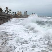
Rekorddyr orkansäsong i USA – skador för biljoner
Sammanlagt uppgår kostnaderna för årets orkansäsong i USA strax under 203 miljarder dollar, motsvarande mer än 1 600 miljarder kronor. Det visar uträkningar av katastrofekonomerna Chuck Watson och Mark Johnson, enligt Bloomberg.
Det gör orkansäsongen, som formellt sett inte är över förrän efter den 30 november, till den dyraste i landets historia. Sedan början den 1 juni har 17 stormar namngivits – 10 av dem uppgraderades till orkaner. Hundratals dog när orkaner som Harvey och Irma drog in över Atlanten.
bakgrund
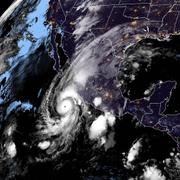
Atlantiska orkansäsongen 2017
Wikipedia (en)
The 2017 Atlantic hurricane season is an ongoing event in the annual formation of tropical cyclones in the Atlantic basin. The season has been hyperactive, featuring 17 named storms, tying it with 1936 as the fifth-most active season since records began in 1851. The season also features both the highest total accumulated cyclone energy (ACE) and the highest number of major hurricanes since the 2005 season. All ten of the season's hurricanes occurred in a row, the greatest number of consecutive hurricanes in the satellite era. In addition, it is by far the costliest season on record, with a preliminary total of over $367.56 billion (USD) in damages, nearly all of which was due to three of the season's major hurricanes — Harvey, Irma, and Maria. This season is also one of only six years on record to feature multiple Category 5 hurricanes. Irma's landfalls on multiple Caribbean islands and Maria's landfall on Dominica made 2017 the second season on record (after 2007) to feature two hurricanes making landfall at Category 5 intensity. In addition, Irma was the strongest hurricane ever recorded to form in the Atlantic Ocean outside of the Gulf of Mexico and Caribbean Sea. Most of the tropical cyclones impacted land but some remained over water without impacting land, including a tropical depression, Tropical Storms Arlene, Don, and Rina, and hurricanes Gert and Lee. This season is the only season on record in which three hurricanes each had an ACE of over 40: Irma, Jose, and Maria.
The season officially began on June 1 and will end on November 30. These dates historically describe the period of year when most tropical cyclones form in the Atlantic basin and are adopted by convention. However, as shown by Tropical Storm Arlene in April, the formation of tropical cyclones is possible at other times of the year. In addition, Arlene was among one of the northernmost pre-season storms on record. In mid-June, Tropical Storm Bret struck the island of Trinidad, which is only rarely struck by tropical cyclones due to its low latitude. A few days later, Tropical Storm Cindy struck the state of Louisiana. In late August, Hurricane Harvey became the first major hurricane to make landfall in the United States since Wilma in 2005, while also setting the record for the costliest tropical cyclone on record, as well as the most rainfall dropped by a tropical cyclone in the US. In early September, Hurricane Irma, a Cape Verde-type hurricane, became the first Category 5 hurricane to impact the northern Leeward Islands on record, later making landfall in the Florida Keys as a large Category 4. In terms of maximum sustained winds, Irma is tied with the 1935 Labor Day hurricane as the strongest hurricane ever to make landfall in the Atlantic basin. In late September, Hurricane Maria became the first Category 5 hurricane to strike the island of Dominica on record. It later made landfall in Puerto Rico as a high-end Category 4. The season also featured the fastest-moving tropical cyclone ever recorded in the Gulf of Mexico (Hurricane Nate). In mid-October, Hurricane Ophelia became the easternmost major hurricane in the Atlantic basin on record, and later impacted most of Northern Europe as an extratropical cyclone.
Initial predictions for the season anticipated that an El Niño would develop, lowering storm activity. However, the predicted El Niño failed to develop, with cool-neutral conditions developing instead, later progressing to a La Niña – the second one in a row. This led to forecasters upgrading their predicted totals, with some later anticipating that the season could be the most active since 2010.
Beginning in 2017, the National Hurricane Center (NHC) has the option to issue advisories, and thus allow watches and warnings to be issued, on disturbances that are not yet tropical cyclones but have a high chance to become one, and are expected to bring tropical storm or hurricane conditions to landmasses within 48 hours. Such systems are termed "potential tropical cyclones". Advisories on these storms contain the same content, including track forecasts and cyclone watches and warnings, as advisories on active tropical cyclones. The first storm to receive this designation was Potential Tropical Cyclone Two, which later developed into Tropical Storm Bret, east-southeast of the Windward Islands on June 18. In addition, the numbering that a potential tropical cyclone receives would be retained for the rest of the hurricane season, meaning that the next tropical system would be designated with the following number, even though potential tropical cyclones do not qualify as tropical cyclones. This was first demonstrated with Potential Tropical Cyclone Ten, which failed to develop into a tropical cyclone.
Omni är politiskt obundna och oberoende. Vi strävar efter att ge fler perspektiv på nyheterna. Har du frågor eller synpunkter kring vår rapportering? Kontakta redaktionen